Waterbury began as the Mattatuck Plantation, a land
grant given to settlers from Farmington, Connecticut in
1676. In addition to Waterbury, the Mattatuck Plantation
included the modern-day Connecticut towns of Naugatuck,
Middlebury, Watertown and Thomaston, and portions of Wolcott,
Plymouth, Oxford and Prospect. The Village of Mattatuck
was settled in 1678 and centered on what is today the
Waterbury Green. Town status was granted in 1686, and
the name Mattatuck was changed to Waterbury.
Waterbury’s population remained small, hovering
at just under 200 people, until the 1720s. The settlers
worked as farmers, carpenters, millers and blacksmiths.
New arrivals were required to gain permission to live
in Waterbury, and normally entered into a contract with
the town in which they promised to reside there for a
minimum number of years while practicing their trade.
Mid-Century Growth
Waterbury’s population grew rapidly in the middle
of the eighteenth century, expanding from 350 people in
1725 to 3,536 people in 1775. During these decades, the
town’s activities focused on construction of bridges
and highways, the building of Meeting Houses, Sabbath-day
houses and schools, tending to the sick and the poor,
and settling boundary disputes with neighboring towns.
The eighteenth century saw the growth of commerce in
Waterbury, as taverns and general stores flourished with
the increase in population. Merchants operated numerous
small businesses, establishing trade with towns throughout
the colony. Several late-eighteenth-century merchants
found success as manufacturers in the early nineteenth
century.
Waterbury’s wealthier families tended to be descendents
of the original settlers, and much of their wealth came
from land ownership. These same families operated general
stores and taverns, and produced many of the town’s
professionals: physicians, attorneys and clergymen. Many
of these prominent families also included slave owners.
The Revolutionary War
Waterbury contributed nearly 700 soldiers to fight against
the British; at least five of those soldiers were African
Americans. Rochambeau's army marched through town, and
George Washington dined in Waterbury on his way to Hartford.
Not all Waterbury residents supported the war. Many people
left to join the English army. Other loyalists remained
in Waterbury until after the war and then moved to Canada.
After the Revolution
The decades following the Revolution saw Waterbury drastically
reduced in size, as its outlying parishes chose to become
incorporated as separate towns. The process for each secession
took many years, requiring permission from Waterbury and
from Connecticut's General Assembly.
In 1780, Westbury and Northbury broke away from Waterbury
and became Watertown; the future towns of Plymouth and
Thomaston were part of Watertown until 1795. Farmingbury
became Wolcott in 1796, and Oxford became a town that
same year. Middlebury, composed of portions of Waterbury,
Woodbury and Southbury, was established as a distinct
society in 1790, but Waterbury blocked its incorporation
as a town until 1807. Columbia (now Prospect) and Salem
(now Naugatuck) became independent towns later in the
nineteenth century.
Despite the loss of so much of its territory, Waterbury
flourished at the end of the eighteenth century. A new
school was constructed in 1785 on the Green, and both
the Congregational and the Episcopal churches constructed
elegant new buildings on the Green in 1795. All three
projects were funded by public subscription. Merchants
began to venture into manufacturing, producing nails,
clocks, pewter buttons and woolens. These ventures flourished
in the nineteenth century, and Waterbury became renowned
for its brass manufacturing industry.
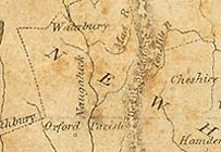
From A New and Elegant General Atlas. Originally
owned by Mark Leavenworth, grandson of Waterbury's Rev.
Leavenworth. Collection of the Mattatuck Museum.
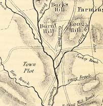
The Old Township of Waterbury
Map originally published in Henry Bronson's The History
of Waterbury, 1858.
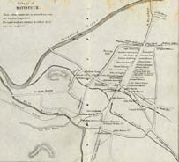
Village of Mattatuck, c. 1683
Map originally published in Henry Bronson's The History
of Waterbury, 1858. North is to the right.
South-eastern view of Waterbury
Engraving by John Warner Barber, originally published
in Connecticut Historical Collections, 1836. The
spire of the Episcopal church is to the left, the Methodist
church is in the center, and the Congregational church
is to the right.
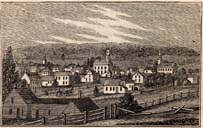
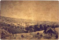
View of Waterbury from Westside Hill
Engraving by Lucien Bisbee, 1835. Collection of the Mattatuck Museum.